
News & Events
September 11, 2018
Learn More About Lightning – Pollution from Shipping Traffic Increases Lightning and Thunderstorm Activity
The Mysteries of Lightning
Even here at NexTek, where we deal with Lightning and Lightning Protection each and every day, we know that there is still a lot to learn about how, why, and where it occurs. While we can track Lightning Activity in real-time around the world (See HERE for an older post on the topic!) and we know about what atmospheric conditions are required to allow a Thunderstorm to form; even experts still do not know why a Lightning Strike “lands” exactly where it does, or all of the factors involved in determining the severity of a Thunderstorm or its’ Lighting activity levels.
Along these lines, we are always interested in seeing new research and learning more about the natural phenomenon that is Lightning. One recent research paper has identified a clear correlation between busy International Shipping Routes and Thunderstorm/Lighting activity levels!
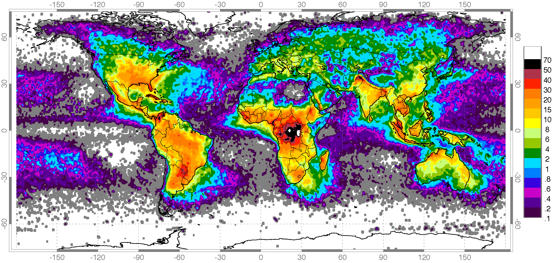
Global Lightning Activity Data
We have long been able to track Lighting Activity with satellites, and use that data to form a Global Lightning Activity level map. See below for a map generated by NASA using data from their satellites in the ’90s and early ’00s, and is colored to show relative hot-spots and cold-spots over a multiple-year time frame.
Shipping Routes vs Local Lightning Activity
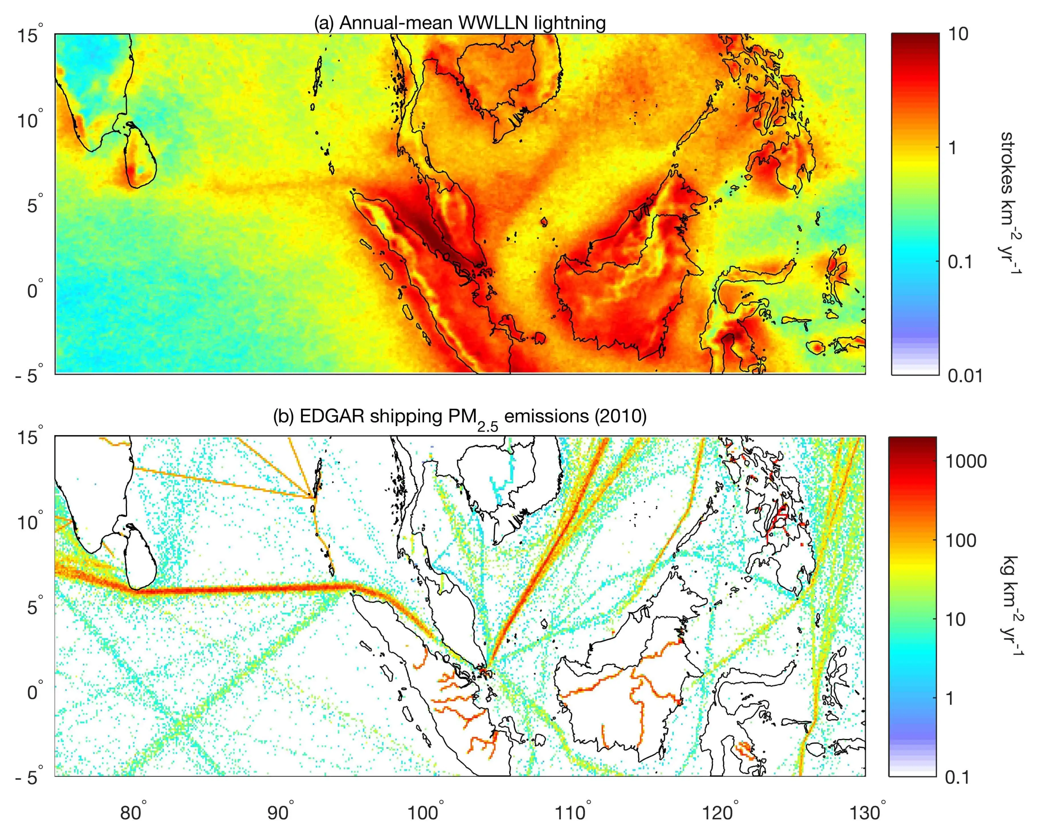
By using more recent Lighting tracking technologies with improved location tracking ability, small variations in Lightning Activity levels in a small area of the world can be identified more clearly. As you can see from the lighting activity map below, there is a very interesting and “unnatural” looking pattern forming between Malaysia and Indonesia that extends with relatively straight lines from either side of this channel (the Malacca Strait.)
When Shipping Emissions patterns for the year 2010 are laid next to the Lightning Map, it does not take long to realize that this corridor of increased strike activity lays exactly over the Shipping Lane that passes through the Malacca Strait. This shipping route is among the busiest, if not the busiest, in the world and ship traffic and therefore ship emissions are elevated in this area at all times.
What Is The Connection?
This paper’s authors make a few guesses as to what the cause of this observed correlation may be, but the most likely factor seems to be the Particulate Emissions emitted by Shipping Vessels on highly-trafficked routes. While the researchers behind this particular study are not exactly sure what connects the two, there are a couple of reasonable hypotheses out there;
- The particulate matter in the exhaust of ships provides a form of “cloud-seeding” which increases cloud formation, rain formation, and therefore increased thunderstorm activity
- This is similar in a sense to jets forming con-trails, where the particulate matter in the exhaust provides something for water to condense on…forming clouds where there were none.
- Perhaps there is an increase in lightning energy or atmospheric charge buildup due to additional particles in the air creating more friction (as experts believe happens during volcanic eruptions)
- Ship exhaust could even be driving an increase the local temperatures and that promotes Thunderstorm creation, or plays some other part that we may not have identified yet.
There is plenty of research still left to do, and much that we will probably never fully understand…But the correlation presented here is striking!
LINKS
Original Press Release from the Researchers behind this Study
Wikipedia – Thunderstorms
Wikipedia – Cloud Seeding
Wikipedia – Dirty Thunderstorms


Get A Free Quote
Or Call 978-486-0582